|
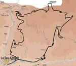
A long, physically demanding, uphill route, which takes
us from the banks of the Segre up to the alpine meadows near to the
Andorra border.
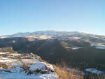
 The
first part of this itinerary as long as spectacular - and international
- follows the track that goes from La Seu to Al�s next to the
river, and later gains altitude by the asphalt road that leads to Estamariu
and Bescaran. The
first part of this itinerary as long as spectacular - and international
- follows the track that goes from La Seu to Al�s next to the
river, and later gains altitude by the asphalt road that leads to Estamariu
and Bescaran.
 In
Bescaran, asphalt road is finished when we follow by the track that
passes next to the roman bell tower of "Sant Mart�",
and that leads to the farms of the village and the grass lands of summer.
On the left, before arriving at the "Pla de Sorri" - from
where we would be able to descend to Torres or Castellnou de Carcolze
- another track leaves, in North direction, that will finish taking
us to the forest of La Rabassa, already in Andorran territory, to the
other slope of the mountain range, where in winter the cross-country
skiing is practiced. There is not a permanent control of borders - although
we have maybe found by the way a patrol of the Civil Guard - and by
this, it has been traditionally a propitious route to the transportation,
we say irregular, of merchandise. In
Bescaran, asphalt road is finished when we follow by the track that
passes next to the roman bell tower of "Sant Mart�",
and that leads to the farms of the village and the grass lands of summer.
On the left, before arriving at the "Pla de Sorri" - from
where we would be able to descend to Torres or Castellnou de Carcolze
- another track leaves, in North direction, that will finish taking
us to the forest of La Rabassa, already in Andorran territory, to the
other slope of the mountain range, where in winter the cross-country
skiing is practiced. There is not a permanent control of borders - although
we have maybe found by the way a patrol of the Civil Guard - and by
this, it has been traditionally a propitious route to the transportation,
we say irregular, of merchandise.
 For
the descent we should return until raising the crest: instead of following
by where we have ascended, we take the track that will take us to the
"Cortals of Boloriu", in west direction. The final part follows
the same way that route 31, by the "Coll de Jou" and Calviny�. For
the descent we should return until raising the crest: instead of following
by where we have ascended, we take the track that will take us to the
"Cortals of Boloriu", in west direction. The final part follows
the same way that route 31, by the "Coll de Jou" and Calviny�.
|