|
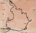
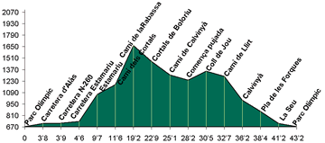
Long, uneven route which ascends through the municipality
of Estamariu, passing through the woods and prairies of Arcavell in
the Valira valley. The return journey passes through Calviny�.
 This
route, that is long and with a little difficulty, will make us cross
a great variety of landscapes, from the plains from the shore to the
forests and the high grazing lands. This
route, that is long and with a little difficulty, will make us cross
a great variety of landscapes, from the plains from the shore to the
forests and the high grazing lands.
 The
first section of the route runs along the river Segre by the way of
Al�s. A little further on - by the N-260 highway - we will find
the deflection that raises to Estamariu and Bescaran. The ascent is
smooth and is compensated by the views of Al�s and Torres, and,
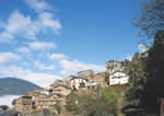
more ahead, on La Seu. We will go by some little farms that there are
on the foot of Estamariu, and, mainly, of the old church of "Sant
Vicen�". As we go up, we will have a good perspective of
the town: houses tightened on a hill and an admirable set of little
fields. The
first section of the route runs along the river Segre by the way of
Al�s. A little further on - by the N-260 highway - we will find
the deflection that raises to Estamariu and Bescaran. The ascent is
smooth and is compensated by the views of Al�s and Torres, and,
more ahead, on La Seu. We will go by some little farms that there are
on the foot of Estamariu, and, mainly, of the old church of "Sant
Vicen�". As we go up, we will have a good perspective of
the town: houses tightened on a hill and an admirable set of little
fields.
 We
will leave the road to take a track that goes to Estamariu's Cortals.
At 1400 meters we already find forests. When we see a diversion in the
road we will have abandoned the term of Estamariu to pass to the one
of Arcavell. The way already is flatter and it will leave soon to Boloriu.
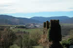
The panoramic opens towards valleys of "Sant Joan", and "El
Ras d'Ars", and the "Sal�ria" peak. The track
would bring us to Arcavell, but we will take one that leaves on the
left and that, by "Coll de Jou", approaches us to Calviny�,
with good views on the Valira valley. From Calviny� to La Seu,
all slope: underneath the town and on the right, if we pay attention,
we will see the "Santa Margarita's bell tower in ruins. A memory
of the old village. We
will leave the road to take a track that goes to Estamariu's Cortals.
At 1400 meters we already find forests. When we see a diversion in the
road we will have abandoned the term of Estamariu to pass to the one
of Arcavell. The way already is flatter and it will leave soon to Boloriu.
The panoramic opens towards valleys of "Sant Joan", and "El
Ras d'Ars", and the "Sal�ria" peak. The track
would bring us to Arcavell, but we will take one that leaves on the
left and that, by "Coll de Jou", approaches us to Calviny�,
with good views on the Valira valley. From Calviny� to La Seu,
all slope: underneath the town and on the right, if we pay attention,
we will see the "Santa Margarita's bell tower in ruins. A memory
of the old village.
|