|
�
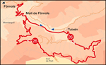
This route follows the roads of the Lavansa valley and along the Mola river with a mid- section over the wild slopes of the Verd mountain range. The route is long, moderately difficult and has varied views, ideal for a late afternoon in summer i.e. when it is cooler but be aware of the time needed
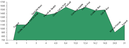
Starting from Mol� de F�rnols, cross over the river in the direction of the campsite. Turn left along the road through the forest up the Lavansa valley to Tuixent. The road ascends gradually through a pine forests until Tuixent. Turn right along the tar road and skirt around Tuixent until you reach a side road which enters the Mola valley. At the intersection there is a fountain where you can refill your water bottle. The road slope gently upwards along the shady side of the valley. Soon after the Planells del Sastr� (where you can barbecue) the road divides. The main road continues to G�sol via the Mola pass but you should take the road to the right. Gain altitude climbing through a thick pine forest on the northern slopes of the Verd mountain range. Keep going west beneath the Sella range until you reach the Pont mountain pass. From here you can go to Sant Lloren� de Morunys or to the Prat de Arp (a cross country ski station) or you can return to Mol� de F�rnols. To return to the Mol�, turn right and descend to the Buc pass. At the Buc pass, turn left (right takes you to Tuixent) and descend to the Mol� de F�rnols through a huge forest.
|