|
�
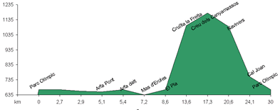
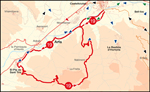
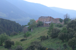 This route is long and, especially on the steep section, physically demanding. The first section of the route, some nine kilometres, is from the Palanca bridge to Pla de Sant Tirs. Follow the old, flat road along the left bank of the Segre that connects Arfa, Mas d' Eroles and Pla de Sant Tirs. From Pla de Sant Tirs, a town which is anything but flat, the real ascent starts which is a test for the legs. Make sure your bicycle has a small climbing cog and is in perfect working order. Follow the steep road (a five hundred-meter climb in six kilometres) through the forest of Pla de Sant Tirs (look at the pines on the ground and in the surrounds). On arriving at cal (house) La Font, you have nearly completed the ascent, continue southwards along a gravel road and turn towards the Fontelles hill. From here follow the flat road in the direction of Creu dels Canyemassos. Before reaching Creu dels Canyemassos you will pass cal Franc, a good example of the isolated self-sufficient houses that have yet to modernise found in the area. La Creu dels Canyemassos is a mountain pass with cultivated fields where several old paths cross and, from here, you can easily reach the upper reaches of the Tost valley. Turn northwards and begin a long and rough descent passing by the deserted village of Nabiners on your left. In front you, in the background you can see the mountains surrounding La Seu d'Urgell, while in the foreground you can see Montferrer and Castellciutat with their old fortifications. On you right you have the valley of the Casanoves and on the left the Coma valley. Descend along a steep gravel road via this valley to the Freita stream. The tar road starts at cal Joan at the end of the valley. This road takes you to the old road to d'Arfa from where you return to the Palanca bridge.
|