|
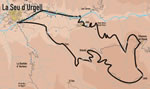
A long, difficult and steep but spectacular route with
magnificent views of the "Cad�". The climb passes through
Al�s, Banat and Vilanova, whilst the descent takes in Orted�
and Cerc.
 A
long route that requests good legs, because the total slope is high
and some of the ascents are hard. But it is worth. A
long route that requests good legs, because the total slope is high
and some of the ascents are hard. But it is worth.
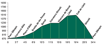
We go up by the track that of Al�s goes up towards the hermitage
of "Santa Maria de les Peces" (route 12) and, passing through
"Cal Marquet", we arrive at Banat. From Banat we will take
the asphalt road between Orted� and Vilanova de Banat.
At
Vilanova we will see the Cad� mountain range, as a bottom drop
curtain: it is not necessary to pay more attention to it because more
ahead we will be able to see it all the time. We will follow by the
track that, passing through "Coll de Cort", crosses the forest
and, already the sunny slope of "El Galliner" (Hen house),
that leads us to the uninhabited village of Llet�. At the bottom
of the valley we can see "La Molina de Llet�", a single
house where there had been a sawmill moved by water force. 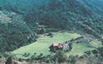
We
go out of Llet� and we go to the west, by the track that goes
to Orted�. At Orted� we will go in front of "Cal
Rib�", a strong house, and we will go down by the asphalt
road until Cerc and La Seu d'Urgell, the starting point.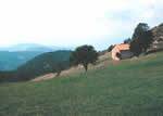
|