|
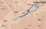
An easy route, with some steeper parts towards the end,
which passes along both of the Segre riverbanks and allows us to contemplate
the chain of hills situated in the heart of l'Urgellet.
 The
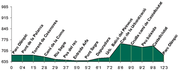
first section of the route, until Arfa, follows the itinerary 13. In
Arfa, instead of continuing to El Pla, we will cross the Segre by a
bridge of medieval origin, and that is one of the few surviving bridges
of the floods in 1982. From this point we will begin to return. We leave
on the left the hill upon there is the town of Montferrer, one old possession
of the bishop of Urgell, where he built a castle to watch the goings
and comings of viscounts of Castellb�. The
first section of the route, until Arfa, follows the itinerary 13. In
Arfa, instead of continuing to El Pla, we will cross the Segre by a
bridge of medieval origin, and that is one of the few surviving bridges
of the floods in 1982. From this point we will begin to return. We leave
on the left the hill upon there is the town of Montferrer, one old possession
of the bishop of Urgell, where he built a castle to watch the goings
and comings of viscounts of Castellb�.
We will leave the shore to rise for the streets of an urbanization.
We are gaining view on mountains of "Nabiners" and "La
Coma" and also on the "Mesclant de les Aig�es",
the point where they come together rivers Segre and Valira. We will
raise until the top. A very pronounced slope that takes us to the "Coll
of Ciutat" - or "La Llengua de Serp", as also it is known.
We go passing for the side of old military installations - "La
Ciutadella" -, that was built at the century XVII to protect the
Castle of Ciutat. Today there is a tourism school.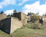
We arrive at Castellciutat, dominated by the castle, that was the
old residence of the counts of Urgell and, later, the most important
fortification of the viscounts of Castellb�, that was transformed
into a modern fortress by the Italian engineer Ambrosio Borsano, in
1692. By the Ciutat bridge we will arrive at the most western sector
of the enlargement of La Seu, to return to the starting point.
|