|
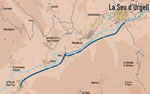
A route through three small towns on the left bank of
the Segre, to the south of La Seu. No problems here: a flat, pleasant
stroll.
 The
route follows the old way that connected the villages of the Urgellet
with La Seu, by the left border of the Segre. The
route follows the old way that connected the villages of the Urgellet
with La Seu, by the left border of the Segre.
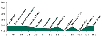
 Passing
the bridge of "La Palanca", and taking the path that goes
to the west, we enter in Esta�, a place-name that remembers us
one old Roman unit. The Segre, in this section, is not canalised and
we will pass through the edge of some furious points. On the hills of
the other band of the river, Castellciutat, Ciutadella and Montferrer.
The valleys that we are finding are: the "Casanoves" and "La
Coma", that are born of the buttocks ranges of the Cad�. Passing
the bridge of "La Palanca", and taking the path that goes
to the west, we enter in Esta�, a place-name that remembers us
one old Roman unit. The Segre, in this section, is not canalised and
we will pass through the edge of some furious points. On the hills of
the other band of the river, Castellciutat, Ciutadella and Montferrer.
The valleys that we are finding are: the "Casanoves" and "La
Coma", that are born of the buttocks ranges of the Cad�.
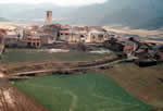
The bell tower of the church of Arfa indicates that we have already
arrived at the town, famous for the Festa Major (greater celebration)
- one of the first of the season - and for its cherries. We leave Arfa
and its steep streets, to continue towards the west by the track that
brings us until El Pla. El Pla - de Sant Tirs - was the site where the
consuls of Urgell were going to receive the bishop when he came to take
possession of the Episcopal see. Before, we will have arrived to Adrall.
At the forests that there are upon the town had been an important mining
activity - coal -, but nowadays is hardly remained. To return we will
undo the going way.
|