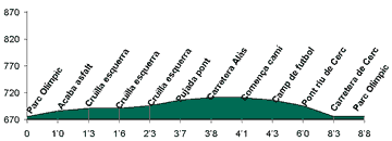
|
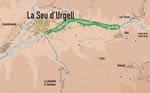
Very flat, gentle route parallel to the River Segre,
between the walkways of La Seu and Al�s, passing through orchards,
meadows and amongst fruit trees.
 A
very flat route that allows to follow the shore of the Segre between
La Seu and Al�s. The route does not present any difficulty: so
the going as the return becomes by the track parallel to the river bank.
One leaves the right margin of the Segre, going along the Parc del Segre
and the parcels where a lot of people from "Alt Urgell" have
their orchards. We leave on the left the districts of "Poble Sec",
"Sant Antoni" and "Sant Pere", on the foot of the
mountains that close by the north the river bank. A
very flat route that allows to follow the shore of the Segre between
La Seu and Al�s. The route does not present any difficulty: so
the going as the return becomes by the track parallel to the river bank.
One leaves the right margin of the Segre, going along the Parc del Segre
and the parcels where a lot of people from "Alt Urgell" have
their orchards. We leave on the left the districts of "Poble Sec",
"Sant Antoni" and "Sant Pere", on the foot of the
mountains that close by the north the river bank.
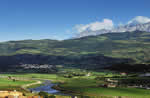
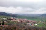 Al�s
is opposite, a little elevated, between meadows. At the bottom of the
village we cross the river by the Al�s bridge to take the other
side track in order to go back La Seu. Near the river we can watch a
lot of species of birds that take advantage of the watercourse to feed
themselves, to nest or to orientate themselves. Al�s
is opposite, a little elevated, between meadows. At the bottom of the
village we cross the river by the Al�s bridge to take the other
side track in order to go back La Seu. Near the river we can watch a
lot of species of birds that take advantage of the watercourse to feed
themselves, to nest or to orientate themselves.
Often, groups of kingfishers can be seen, in the large fields that
remain on the left of the trail, well quiet. Going back to La Seu we
can observe the east front profile of the town, dominated by the Cathedral,
with the apse flanked by the two big unfinished towers. Far end, Castellciutat,
with the XVII century fortresses and the mountains range that leads
to the Pallars.
|