|
23h 50 ' |
222,3 Km |
6.180 m |
|
|
|
�
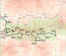
La Seu d'Urgell - F�rnols
�
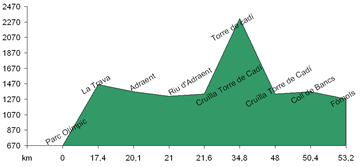
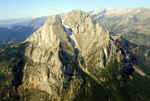
 This stage of the route, which is hilly, takes you to the ridge of the Cad�. The route is difficult but is mainly on tar roads and offers magnificent views along the way. Leave La Seu d�rgell along the small road to Cerc. Soon after leaving Cerc turn right in the direction of Ges and the viewing point of La Trava, one of the best in the Alt Urgell. Drop down a little into the village of Adra�n. Shortly after leaving Adra�n, turn left onto a steep gravel road which, via a series of switch backs, takes you up to the Collada (saddle) del Pelat and, further on, the Collada del Pradell. Here you will find a wire fence and the summit of the Cad�, at 2,320 meters above sea level. The views from here are exceptional. Return along the same route to the intersection and turn left. Pass Coll (col) de Bancs and continue until you reach F�rnols in the valley of the Lavansa. This stage of the route, which is hilly, takes you to the ridge of the Cad�. The route is difficult but is mainly on tar roads and offers magnificent views along the way. Leave La Seu d�rgell along the small road to Cerc. Soon after leaving Cerc turn right in the direction of Ges and the viewing point of La Trava, one of the best in the Alt Urgell. Drop down a little into the village of Adra�n. Shortly after leaving Adra�n, turn left onto a steep gravel road which, via a series of switch backs, takes you up to the Collada (saddle) del Pelat and, further on, the Collada del Pradell. Here you will find a wire fence and the summit of the Cad�, at 2,320 meters above sea level. The views from here are exceptional. Return along the same route to the intersection and turn left. Pass Coll (col) de Bancs and continue until you reach F�rnols in the valley of the Lavansa.
�
F�rnols - Bag�
�
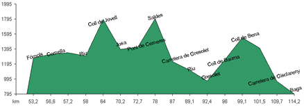
 The second stage, the longest of the route, has more gravel road and has a considerable descent. From F�rnols, continue in the direction of Cornellana. At the turning to Cornellana, turn left along a gravel road that follows the river Ribanegra, which has the Cad� to the north and the peak Cadinell to the south, until the Coll de Jovell. Continue down the same path towards Josa. At the intersection shortly before Josa, turn right on the road towards Gos�l. At the Pont (bridge) de Cerneres, turn left along a gravel road which is flat to begin with but becomes steeper and rockier. Here we leave the region of Collel and enter the region of Bergued�. Turn right on to the road that slopes down gently and leads to the spectacular Gresolet viewing point in front of the peak Pedraforca to the south. Continue along the tar road towards Saldes. After crossing the Pont de Saldes turn left onto a gravel road that follows the Gresolet stream. Pass the sanctuary and climb the Collado de Bauma. Continue downwards past the Collado de la Bena entering into the Bastareny valley all the way to Bag�. The second stage, the longest of the route, has more gravel road and has a considerable descent. From F�rnols, continue in the direction of Cornellana. At the turning to Cornellana, turn left along a gravel road that follows the river Ribanegra, which has the Cad� to the north and the peak Cadinell to the south, until the Coll de Jovell. Continue down the same path towards Josa. At the intersection shortly before Josa, turn right on the road towards Gos�l. At the Pont (bridge) de Cerneres, turn left along a gravel road which is flat to begin with but becomes steeper and rockier. Here we leave the region of Collel and enter the region of Bergued�. Turn right on to the road that slopes down gently and leads to the spectacular Gresolet viewing point in front of the peak Pedraforca to the south. Continue along the tar road towards Saldes. After crossing the Pont de Saldes turn left onto a gravel road that follows the Gresolet stream. Pass the sanctuary and climb the Collado de Bauma. Continue downwards past the Collado de la Bena entering into the Bastareny valley all the way to Bag�.
�
Bag� - Martinet
�
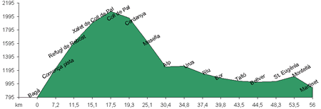
 This stage is easier and less hilly than the previous stages with more tar road. Leave Bag� via the road to Col de Pal. Turn left onto a gravel road that leads to L'Hospitalet de Roca San�a and up the Collado de la Gavarra, with a view of the Moixer�, Pass the Rebost refuge and climb the Collada de la B�fina. Turn left at the intersection with the tar road (which you previously left) and climb the collada de Pal where the road changes to gravel. Climb the collada de la Mola passing the path off to the right that leads to La Molina. From here the road slopes downwards across the Pleta de les Baques until you reach the intersection of the road between La Molina (right) and Masella (left). Cross over the road and continue down a path leading to the bosc (forest) de la Pleta and les Deveses. On reaching the road between Masella and Alp, turn left towards Das, not on the main road but rather on an alternative one on the left. On reaching Das, turn left along the main road leading to the tunnel del Cad�. Turn left into the town of Ur�s and at the church turn left again and follow a narrow tar road that takes you to the rest area of the tunnel del Cad� and Riu de Cerdanya. Continue along this road down to Pedra and Bor. Shortly after Bor turn left along a path that takes you past Moli Pons and Cal Pons. After Cal Pons turn right on the tar road that takes you past Tall� to Bellver de Cerdanya. From here take the road to Pi. Pass the Cucs (worms) fountain and turn right along a gravel road that intersects the road between Pi - Oli� and Nas. Turn right towards Santa Eug�nia and Montell�. Cross over the Ridolaina stream to reach Montell�. Continue on down toward Martinet on a wider road.� This stage is easier and less hilly than the previous stages with more tar road. Leave Bag� via the road to Col de Pal. Turn left onto a gravel road that leads to L'Hospitalet de Roca San�a and up the Collado de la Gavarra, with a view of the Moixer�, Pass the Rebost refuge and climb the Collada de la B�fina. Turn left at the intersection with the tar road (which you previously left) and climb the collada de Pal where the road changes to gravel. Climb the collada de la Mola passing the path off to the right that leads to La Molina. From here the road slopes downwards across the Pleta de les Baques until you reach the intersection of the road between La Molina (right) and Masella (left). Cross over the road and continue down a path leading to the bosc (forest) de la Pleta and les Deveses. On reaching the road between Masella and Alp, turn left towards Das, not on the main road but rather on an alternative one on the left. On reaching Das, turn left along the main road leading to the tunnel del Cad�. Turn left into the town of Ur�s and at the church turn left again and follow a narrow tar road that takes you to the rest area of the tunnel del Cad� and Riu de Cerdanya. Continue along this road down to Pedra and Bor. Shortly after Bor turn left along a path that takes you past Moli Pons and Cal Pons. After Cal Pons turn right on the tar road that takes you past Tall� to Bellver de Cerdanya. From here take the road to Pi. Pass the Cucs (worms) fountain and turn right along a gravel road that intersects the road between Pi - Oli� and Nas. Turn right towards Santa Eug�nia and Montell�. Cross over the Ridolaina stream to reach Montell�. Continue on down toward Martinet on a wider road.�
�
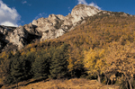
Martinet - La Seu d'Urgell
�
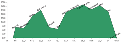
 The final leg of your journey is shorter and more gentle but should not be discounted as two thirds of this leg is along gravel roads. While cycling look at the magnificent views of the northern side of the Cad�. From Martinet, turn left along the road to Montell� and shortly afterwards take the road (right) in the direction of d'Estana and Bastanist. Shortly afterwards again, turn right after crossing the Cabiscol stream along a narrow road that passes through the l'estret (narrows) de Mollet where you enter the region of the Alt Urgell. Pass the houses at Arenys and turn left at the intersection with the tar road up the hill towards Toloriu. Pass Bar on the left and enter into Toloriu. Take the road that leads to the coll de Jou and follow the Fenella stream to Ars�guel. At Ars�guel, turn left along the tar road in the direction of Cava and Ansovell. At the next junction turn right towards Ansovell. Pass through and continue along the gravel road in the direction of the Boscal sanctuary where you will see a sensational view of the Cad�. Take the path that runs along the base of the Cad� towards coll de Vanses skirting around the tur� (hill) dels Castellassos. From coll de Vanses descend along the Toscarre valley through the Bentanacs forest until you intersect the d'Orted� - La Seu d'Urgell road. Turn left and descend past Cerc until La Seu d'Urgell. The final leg of your journey is shorter and more gentle but should not be discounted as two thirds of this leg is along gravel roads. While cycling look at the magnificent views of the northern side of the Cad�. From Martinet, turn left along the road to Montell� and shortly afterwards take the road (right) in the direction of d'Estana and Bastanist. Shortly afterwards again, turn right after crossing the Cabiscol stream along a narrow road that passes through the l'estret (narrows) de Mollet where you enter the region of the Alt Urgell. Pass the houses at Arenys and turn left at the intersection with the tar road up the hill towards Toloriu. Pass Bar on the left and enter into Toloriu. Take the road that leads to the coll de Jou and follow the Fenella stream to Ars�guel. At Ars�guel, turn left along the tar road in the direction of Cava and Ansovell. At the next junction turn right towards Ansovell. Pass through and continue along the gravel road in the direction of the Boscal sanctuary where you will see a sensational view of the Cad�. Take the path that runs along the base of the Cad� towards coll de Vanses skirting around the tur� (hill) dels Castellassos. From coll de Vanses descend along the Toscarre valley through the Bentanacs forest until you intersect the d'Orted� - La Seu d'Urgell road. Turn left and descend past Cerc until La Seu d'Urgell.
|